April fools! Outlooks for this chase day in northwest Texas didn’t promise a whole lot. The chance of tornadoes was relatively low, and hailstorms were the most significant threat. At the end of the day, although no tornadoes occurred we were treated to quite a lightning and structure show. There was even a gustnado (small non-tornadic area of swirling dust and high winds associated with gust fronts) that chased us down Highway 82!
As we approached the storm, we were greeted by a mean-looking wall cloud that seemed like it wanted to drop a tornado at any minute.
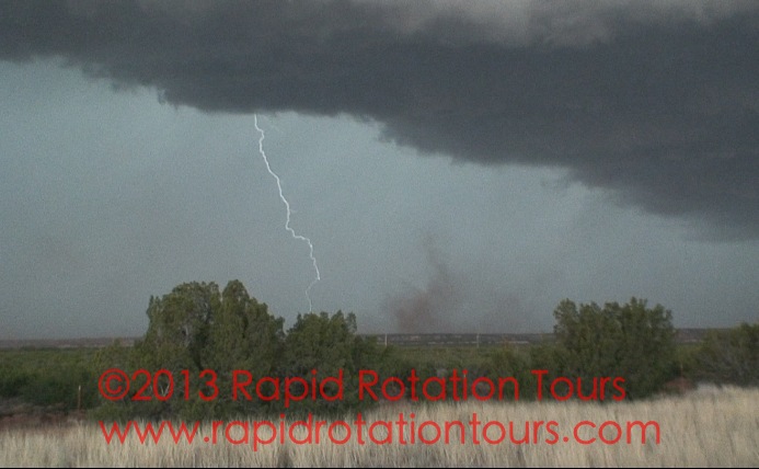
We pulled off the road for some CG (cloud to ground) lightning strikes while we waited for the storm to get a bit closer.
We found a better vantage point among cacti and barbed wire to watch the whole supercell tighten up. (Note: when chasing in NW Texas, beware of rattlesnakes!)
Gustnadoes can still be a damaging threat, so we snapped a few shots and grabbed some video before it had a chance to chase us too far down 82. For a day that didn’t hold a lot of promise, it was still a gorgeous storm and one heck of an adrenaline rush!
I think it’s safe to say that when most people think of tornadoes, they immediately think of the Great Plains of America. While the central U.S. is the undisputed tornado capital of the world, they can occur literally anywhere. There are LOTS of tornado reports every year from all over the planet. They are common in Australia, southern Asia, South America, and even Europe.
The map below, courtesy of the European Severe Weather Laboratory, shows all the tornado and funnel cloud reports in Europe between September 1 and December 6. 130 reports in all!
1 Sep – 6 Dec 2012
Admittedly, many of these reports are waterspouts that occasionally come onshore and cause damage to coastal communities and property. A great example of one of these picturesque waterspouts occurrred off the coast of Italy on December 2. Very impressive waterspout!
Other tornadic activity outside the U.S. in the past few weeks includes:
This tornado today near Auckland, New Zealand, that unfortunately took the lives of three people.
This tornado in Portugal on November 16. Impressive but dangerous vantage point for the cameraman as the tornado all but destroys this small soccer stadium. This person should have sought shelter instead of filming this. Way too close!
And that brings us to the amazing and violent tornado that struck Taranto, Italy on November 28. This is a small industrial city in the southeast part of the country, on the “boot heel.” This was a violent tornado in an urban setting, which is an awful combination. This first video clip is from a very close vantage point, and debris can clearly be seen being thrown about by this massive funnel. This is great footage of the structure of the tornado itself as well.
The following is another vantage point of the same massive tornado, and is easily the best tornado footage I have seen come out of Europe. If I was watching this video without any context and didn’t know any better, I would have guessed this to be from Kansas or Oklahoma. This footage, at least from the point of view of a storm chaser, is nothing short of amazing! Note the power flashes as well. This was quite a rare event.
This just goes to show that tornadoes are not a phenomenon limited only to North America. That being said, they occur with most frequency here in the central U.S., and we have the road network and terrain that is perfect for chasing! Come on a tour with us and we’ll show you the most extreme weather on the planet!
We want to extend a big thank you to everyone who came by and visited us at the National Weather Festival on Saturday, November 3rd! Overall, the festival had a big turnout. It was great to see so many people excited about storm chasing and amped up about the idea of storm chasing tours. One booth visitor was so excited that she pointed from across the festival, exclaimed, “This is on my bucket list!! I have to do this!!” and ran over to our booth. Our tornado highlight footage from the past several seasons entranced folks as they walked by. You can see some of the same footage here!
Tour guides Chris McBee and Damon Bearden at our booth.
This is a great time to mention that we still have seats available on all ten of our 2013 tours! Whether you’d rather chase early-season storms in April, the height of the season in May in Oklahoma and Kansas, or the summer season in the North in June, we have you covered.
And as an additional thanks to all our NWF visitors, we’re extending our promotion through November 30th! How would you like to give someone the ultimate gift? A $500 deposit holds your seat, with the remaining $2100 due by March 15, 2013. This makes Rapid Rotation the best value you’ll find if storm chasing tours are in your plans. We hope you’ll add storm chasing to your bucket list and join us in 2013! Sign up today!
The National Weather Festival is this Saturday at the National Weather Center in Norman, Oklahoma from 9-1! Are you ready to meet and greet with storm chasers from all over the country? Rapid Rotation Tours will be there, so look for our booth!
Storm chasers Chris McBee and Damon Bearden will be there to answer questions, as will Rapid Rotation’s designer and photographer Rachel Sager.
Will we see you at the National Weather Festival? The fun goes from 9am-1pm on Saturday, November 3 at the National Weather Center in Norman, OK. Stop by the Rapid Rotation Tours booth and chat with the team! You can meet the tour guides, get information about tours, and ask us any questions you might have. Enjoy a day among like-minded weather enthusiasts!
Tour guide Chris McBee has been a part of the NWF in past years, and has entered the storm chaser car show on more than one occasion. He even won an award for best-looking chase vehicle at the 2009 festival!
Let’s get social. Are you on Twitter or Facebook? We’d love for you to join the conversation! Get the latest about upcoming tours, and live updates during storm chases in progress. Did you see weather happen where you live? Snap a pic, send it to us on social media, and we’ll be happy to post it. We’re listening, and we want to know what you think!
Be sure to follow us on both for information about tours as we approach storm season! We’ll also talk about severe weather in general, warn people in areas where severe weather is occurring, and make sure you know about the latest developments and updates here at Rapid Rotation.
Damon Bearden and I journeyed to eastern New Mexico and west Texas on October 12 for a fall chase. We spent some time in Clovis, New Mexico meeting up with Kris Nation, a meteorologist with KFDA News Channel 10, the CBS affiliate in Amarillo. We’ve chased with the KFDA team on several occasions in the past. We find the opportunity to chase with members of the news media very rewarding. It enables us to better document the severe weather we observe, and it provides the media with more information about the weather situation to relay to their audience.
True to 2012, the day started out slow but we, along with many other chasers, stayed patient and waited. However, the storms did not begin to strengthen until after dark, and that’s not the safest time when you would want to chase storms. Tornadoes were spotted that night, but by a select few chasers. We took the daylight footage we had of the slowly developing storms and began the long journey back home to Norman.
We briefly chased a supercell near Plainview, Texas. It was quite picturesque at the base of the panhandle. While we didn’t see any October tornadoes that day, we witnessed some great storm structure and met up with some fun folks in the media.
Have you ever wondered why the weather world seems to be all about severe weather from April to June? Why does one part of North America appear to get more storms than others, only for the bullseye to shift geographically a month or so later? This is the phenomenon of Severe Weather Season. We’ll chase from Dixie Alley to Tornado Alley, and that’s why our tour home base relocates at the end of the season.
March
Get ready for hills and humidity; the greatest threat for tornadoes lies in the Deep South. From Austin, TX to Sweet Home Alabama, we’ll take a trip almost as far as the Great Smoky Mountains. Don’t let the beautiful terrain fool you, however. This is some of the most dangerous chasing territories. The storms are fast and the foliage is dense, so we’ll play it safe and try to get you the best view…from a distance.
April-May
Less travel and more twisters? We may not travel far to see picturesque tornadoes and supercell thunderstorms. Severe weather begins to shift westward and makes itself right at home in the center of the country. While April may be a little more focused on Arkansas and May goes vertical (South Dakota to Texas), the bullseye stays firmly planted on Oklahoma. There’s a reason these tour dates sell out the fastest!
June
Rocky Mountain High-based supercells should be on everyone’s bucket list. While the tornado risk is still greatest from Nebraska to Oklahoma, we don’t like to rule out the risk of a High Plains outbreak. Most common in June and still possible in July, Colorado’s Palmer Divide and Continential Divide make great backdrops for slow-moving, picturesque supercells. What’s this area’s secret? One word: Upslope.
Curious as to your city’s tornado risk each month? The Weather Channel has the tornado threat mapped out as accurately as Mother Nature allows.
Did we help you decide on a tour date? Sign up today!